San Juan, the capital of Puerto Rico is the oldest
city on US territory (St. Augustine, Florida the oldest city in the
continental). Founded in 1521 by Juan Ponce de León, who named it
City of Puerto Rico ("Rich Port").
The history of San Juan begins a long time before
its official foundation, in 1493, during his second voyage,
Christopher Columbus landed in Puerto Rico. He named the island "San
Juan Bautista", in honor of John the Baptist. But was not until
1508, that the Spanish government appointed Juan Ponce de León as
the first governor of the island. He founded the original settlement
in Caparra, now known as Pueblo Viejo, behind the almost land-locked
harbor just to the west of the present metropolitan area and the
city quickly became Spain's most important military outpost in the
Caribbean.
A year later, the original settlement was
relocated to a nearby coastal islet (to the site of what is now
called Old San Juan) and named Puerto Rico (Rich Port). Sometime
during the 1520s, confusion over the names led to a switch, the
island took the name of Puerto Rico and the town became San Juan.
Today, San Juan is known as "La Ciudad
Amurallada" (the walled city) and is one of the biggest and
best natural harbors in the Caribbean and is the second oldest
European-founded city in the Americas (after Santo Domingo, which
was officially founded on August 5, 1498.)
| Land Area: |
47.5 sq mi (122 sq km) |
| Water Area: |
75.4 sq km (29.11 sq mi) |
| Population: |
420,326 (est. July 1, 2009) |
| Density: |
2,110 per sq km (5,465 per sq mi) (est.
2009) |
| Housing Units: |
182,101 (2000) |
| Housing Density: |
3,808.4 (2000) |
| Per Capita Income:
|
$12,437 (2000) |
| Coordinates: |
Latitude 18°29'00" N Longitude
66°08'00" W |
| ZIP Codes: |
00901, 00902, 00906, 00907, 00908, 00909,
00910-00917, 00919, 00920-00929, 00930, 00931, 00933, 00934,
00936, 00940 |
San Juan is located in the Northern Coastal Plains region in the
karst zone, north of Aguas Buenas
and Caguas;
east of
Bayamón; and west of
Carolina
and
Trujillo Alto.
The metropolitan area known as San Juan has 3
distinct areas: Old San Juan, the Beach & Resort area, and other
outlying communities, the most important: Río Piedras, Hato Rey,
Puerta de Tierra, and Santurce. Río Piedras was founded in 1714 but
became incorporated into San Juan in 1951.
During the early 16th century, San Juan was the
point of departure of Spanish expeditions to charter or settle
unknown parts of the New World. Its fortifications repulsed the
English navigator Sir Francis Drake in 1595, as well as later
attacks.
In the 20th century the city expanded beyond its
walled confines, known as Old San Juan, to incorporate suburban
Miramar, Santurce, Condado, Hato Rey and Río Piedras.
San Juan is the largest processing center of the
island, the metropolitan area has facilities for petroleum and sugar
refining, brewing and distilling and produces cement,
pharmaceuticals, metal products clothing, and tobacco. The port is
one of the busiest in the Caribbean. San Juan is the country's
financial capital, and many U.S. banks and corporations maintain
offices or distributing centers there. San Juan is center of
Caribbean shipping and is the 2nd largest sea port in the area
(after New York City).
Anthem:
En Mi
Viejo San Juan
Wards: Caimito, Cupey, Hato Rey, Monacillos, Old
San Juan, Puerto Nuevo, Quebrada Arenas, Río Piedras, Santurce,
Sabana Llana and Tortugo.
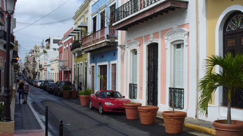
This is a 465-year-old neighborhood originally conceived as a
military stronghold. Its 7-square-block area has evolved into a
charming residential and commercial district. The streets here are
paved with cobbles of adoquine, a blue stone cast from furnace slag;
they were brought over a ballast on Spanish ships and time and
moisture have lent them their characteristic color. The city
includes more than 400 carefully restored 16th- and 17th-century
Spanish colonial buildings. The Old San Juan attracts many tourists,
who also enjoy the gambling casinos, fine beaches, and tropical
climate. More tourists visit San Juan each year than any other spot
in the Caribbean. A leisurely foot tour is advisable for those who
really want to experience this bit of the Old World, especially
given the narrow, steep streets and frequently heavy traffic. To
really do justice to these wonderful old sites, you'll need two
mornings or a full day.
Old San Juan has several plazas: Plaza de San José
is a favorite meeting place for young and old alike. At its center
stands the bronze statue of Ponce de León, made from a British
cannons captured in during Sir Ralph Abercromby's attack 1797. The
plaza is skirted by a number of historic buildings.
Abutting Plaza San José is the Plaza del Quinto
Centenario (Quincentennial Square), opened in October 12,
1992. This plaza is the cornerstone of Puerto Rico's commemoration
of the 500th anniversary of Columbus' discovery of the New World,
has a sculpture which rises 12 meters (40 feet). The monumental
totemic sculpture in black granite and ceramics symbolizes the
earthen and clay roots of American history and is the work of Jaime
Suarez, one of Puerto Rico's foremost artists.
Plaza de Armas (arms square) is Old San Juan's
main square, on San José Street. Features four statues representing
the four seasons; all are over 100 years old. It was carefully
planned as the main city square and has served as a social meeting
place for generations.
Plaza de Colón (Columbus square) was originally
called St. James Square was renamed in 1893 to honor Christopher
Columbus on the 400th anniversary of his discovery of Puerto Rico;
bronze tablets at the pedestal of the Columbus statue record
important episodes in the explorer's life.
Plazuela de la Rogativa (plaza of the
procession) was built in 1971, features a modern sculpture depicting
a procession of religious women commemorates an event that took
place on the site in 1797. During the spring of that year, a fleet
of British ships led by under Sir Ralph Ambercrombie sailed into San
Juan Bay, meaning to launch an assault on the city and take control
of the colony. When the attack was foiled, they undertook a naval
blockade of San Juan, hoping to starve the residents into
submission. As the towns people began to despair of any help from
soldiers garrisoned in the inland towns, the governor ordered a
rogativa, or divine entreaty, to ask the saints for assistance. The
women of the town formed a procession through the streets, carrying
torches and ringing bells. The British, hearing the commotion and
seeing the moving lights, decided that reinforcements had arrived
and quickly sailed off.
The Plaza de Hostos is located near La Casita,
features artisan displays, snack stands, and traditional piragüeros,
who sell shaved ice topped with tropical fruit syrup.
Parks
The Parque de las Palomas (pigeon park) is
located at the top of the city wall, this park overlooks the
restored La Princesa Jail, now a government office with an
attractive art gallery. The park is the perfect spot from which to
enjoy a magnificent view of the harbor, city and mountains.
The Muñoz Rivera Park is an spacious ocean side
park with large trees, landscape gardens and wide walks, located on
Jesús T. Piñero Avenue. Open Tues-Sun 9:00am - 5:00pm.
Other parks include: Martí Coll Linera Park, and Central Park
(with facilities for jogging, baseball, calisthenics and tennis).
Forts
El Morro,
the word itself sounds powerful and this six-level fortress
certainly is. Begun in 1540 and completed in 1589. San Felipe del
Morro was named in honor of King Phillip II. Most of the walls in
the fort today were added later, in a period of tremendous
construction from the 1760's-1780's. Rising 140 feet above the sea,
its 18-foot-thick wall proved a formidable defense. It fell only
once, in 1598, to a land assault by the Earl of Cumberland's forces.
The fort is a maze of tunnels, dungeons, barracks, outposts and
ramps. El Morro is studded with small, circular sentry boxes called
"garitas" that have become a national symbol. The views of
San Juan Bay from El Morro are spectacular. The area was designated
a National Historic Site in February, 1949 with 74 total acres. It
has the distinction of being the largest fortification in the
Caribbean. In 1992, the fortress was restored to its historical form
in honor of the 500th anniversary of the discovery of Puerto Rico by
Christopher Columbus. El Morro Fortress is a National Historic Site
administered by the National Park Service. The fort is open to the
public daily from 9am to 5pm; (787) 729-6960.
Castillo de San Cristóbal
(San Cristóbal Fort) is El Morro's partner in the city's
defense. Built in 1634 (completed in 1771), was considered the
Gibraltar of the West Indies. San Cristóbal was supported by a
massive system of outworks which provided defense in depth and is is
one of the largest defenses ever built in the Americas. It rose 150
feet, covering 27 acres of land. As if its size and height weren't
sufficient to intimidate enemies, its intricate modular design was
sure to foil them. A strategic masterpiece, it features five
independent units, each connected by moat and tunnel; each fully
self-sufficient should the others fall. It's a
World Heritage and National Historic Site, administered by the
U.S. National Park Service. Open daily from 9am to 6pm; (787)
729-6960.
The Fuerte San Gerónimo (San
Gerónimo Fort) was built on the opposite end of San Juan to
strengthen the city's defenses. The fort is located behind the
Caribe Hilton Hotel, with small military museum in Puerta de Tierra.
The Santa Elena Battery building
with a long chimney-topped bunker was the formal army storage area.