Maps & Overviews of the Parks

Arizona Flag    Utah Flag
     
This page has a short fact sheet for each of the following: the Grand Canyon in Arizona, Bryce Canyon & the Zion National Park in Utah.
Space.

Grand Canyon National Park

 
The Grand Canyon is a steep-sided canyon carved by the Colorado River in the United States in the state of Arizona. It is largely contained within the Grand Canyon National Park, one of the first national parks in the United States. President Theodore Roosevelt was a major proponent of preservation of the Grand Canyon area, and visited it on numerous occasions to hunt and enjoy the scenery.

The Grand Canyon is 277 miles (446 km) long, up to 18 miles (29 km) wide and attains a depth of over a mile (1.83 km) (6000 feet). Nearly two billion years of the Earth's geological history have been exposed as the Colorado River and its tributaries cut their channels through layer after layer of rock while the Colorado Plateau was uplifted. While the specific geologic processes and timing that formed the Grand Canyon are the subject of debate by geologists, recent evidence suggests the Colorado River established its course through the canyon at least 17 million years ago.[4] Since that time, the Colorado River continued to erode and form the canyon to the point we see it at today.

Before European immigration, the area was inhabited by  who built settlements within the canyon and its many caves. The Pueblo people considered the Grand Canyon ("Ongtupqa" in Hopi language) a holy site and made pilgrimages to it. The first European known to have viewed the Grand Canyon was García López de Cárdenas from Spain, who arrived in 1540.

Space.  

Bryce Canyon

 
Bryce Canyon National Park (pronounced /ˈbraɪs/) is a national park located in southwestern Utah in the United States.

The major feature of the park is Bryce Canyon which, despite its name, is not actually a canyon but a giant natural amphitheater created by erosion along the eastern side of the Paunsaugunt Plateau.

Bryce is distinctive due to geological structures called hoodoos, formed by wind, water and ice erosion of the river and lake bed sedimentary rocks.

 The red, orange and white colors of the rocks provide spectacular vistas for park visitors.

Bryce is at a much higher elevation than nearby Zion National Park. The rim at Bryce varies from 8,000 to 9,000 feet (2,400 to 2,700 m).

The Bryce area was settled by Mormon pioneers in the 1850s and was named after Ebenezer Bryce, who homesteaded in the area in 1874.

The area around Bryce Canyon became a U.S. National Monument in 1923 and was designated as a national park in 1928.

The park covers 56 square miles (145 km2) and receives relatively few visitors compared to Zion National Park and the Grand Canyon, largely due to its remote location.

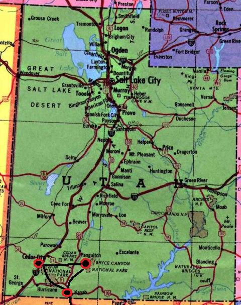
The town of Kanab, Utah, is situated at a central point between these three parks.

Space.  

Zion National Park

 
Zion National Park is a national park located in the Southwestern United States, near Springdale, Utah. A prominent feature of the 229-square-mile (593 km2) park is Zion Canyon, 15 miles (24 km) long and up to half a mile (800 m) deep, cut through the reddish and tan-colored Navajo Sandstone by the North Fork of the Virgin River.

The lowest elevation is 3,666 ft at Coal pits Wash and the highest elevation is 8,726 ft at Horse Ranch Mountain. Located at the junction of the Colorado Plateau, Great Basin, and Mojave Desert regions, the park's unique geography and variety of life zones allow for unusual plant and animal diversity.

Numerous plant species as well as 289 species of birds, 75 mammals (including 19 species of bat), and 32 reptiles inhabit the park's four life zones: desert, riparian, woodland, and coniferous forest.

Common plant species include cottonwood, Cactus, Datura, Juniper, Pine, Boxelder, Sagebrush, yucca, and various willows. Notable mega fauna include mountain lions, mule deer, and Golden Eagles, along with the reintroduced Bighorn Sheep. Zion´s also has rare and endangered species such as the Peregrine Falcon, Mexican spotted owl, California condor, desert tortoise, and the Zion snail, found nowhere else on earth.

Zion National Park includes mountains, canyons, buttes, mesas, monoliths, rivers, slot canyons, and natural arches.


Leon's trip information:


My boss from Fireman's Fund, can you believe it, we worked together in1968, sent me the following information when he visited the canyons!  He said:

Bryce and Zion are anything but boring.  I found Bryce the most interesting.  I did the same trip that you are doing except that we went from Los Vegas to St. George.  We stayed in St. George for 3 nights  and St. George made the perfect starting place.  (I've never seen more kids in any place in my life.  I now know what the Mormons do with their spare time.) Zion is about a 2 hour drive from St. George. The shuttle only goes to the west part of the park.  There are many stops and you can get out at each stop and spend as much time as you like and then take the next shuttle or walk to the next stop.  All in all we probably spent 4 hours.  The most interesting part of Zion you have to drive to.  That's the part where you drive through all the tunnels carved through the red rocks. All tunnels have "windows" carved in them so that you can see the Virgin river canyon and hills. There are places to stop and get out of the car and take pictures.    If you stay on that road it will take you To Bryce. We didn't do it that way, because we were both tired and hungry, and I had slipped in the wet clay and taken a pretty bad fall and I was pretty sore.  My own fault, I was wearing sandals instead of good walking shoes.  Live and learn.  We went back to St. George, enjoyed several brandies in front of the fire place and barbecued a couple of steaks.  The next day we went to Bryce and instead of going back to Zion we continued up highway 15 and cut over to 12.  I'm glad we did it that way because we got to see Red Rock state park which was very interesting. 

You don't need a shuttle in Zion.  You drive to each of many stops, each with spectacular views of the rocks that adorn the area.  We spent 4 or so hours looking and taking pictures.  Be sure to stop at the information centers in both parks as they have lots of information and great maps of the parks.   When we left Zion we took highway 12  and then 89 and 9 into Zion and went through to tunnels.  We decided not to go the Grand Canyon as we were due in Pinetop, AZ and were weren't sure how long it would take us, instead we cut over to Page and went to Lake Powell and took a tour of the dam.  The canyon that the dam blocks is really deep and quite a sight.  Highway 89 and 89A are both pretty good roads, and when we were there (which was  in the fall), neither had a lot of traffic.  If you are going to see both parks in one day you are really going to have hustle your buns.
 
Say hello to your sister for me.  Hope you have a great  time and enjoy the parks as much as we did. 

Space.  
Space.  

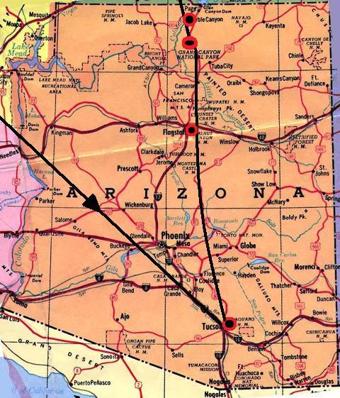
Maps:

Space.
Map to the town of Kanab - Ideally just before Zion and Bryce Canyon
Space.

Space.
Arizona Utah
Space.  

Space.


Space.


Return to the South West Canyons Home Page

Space.


Created by Charles W. Buntjer

Published on: 2010.10.01

Space.

        San Francisco

  Revised on: 2010.10.01..