|
|
|
|
|
|
|||||
| Space. | |||||
|
|
|
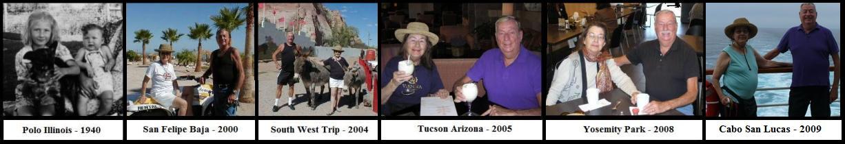
Daily Diary of Our Vacation: |
|||||
| San | |||||
|
San Francisco to Tucson Arizona & the Car Pickup. |
|||||
| San | |||||
|
September 21, 2010 |
Day 1:
I went to the San Francisco airport (S.F.O.) to go to Tucson
on South West Airlines and got there an hour early to have a coffee and
croissant. Well suddenly the time went from 10:30 a.m. to 11:30
a.m. and then to 1:00 p.m. Excuse me.
So I rushed to the desk and they put me on a flight to San Diego and a plane change to Tucson. By the time I rented a car and got to my sister's house I could have flown to London!
The Fox
Plaza Apartment complex is just completing a new exterior paint job.
I left at eight A.M. from the 28th floor for the San Francisco
International Airport and as I was leaving I looked out the window and I saw an advertizing blimp fly by!
On the left is the Mark Hopkins Hotel. The building to it's right
is the Fairmont Hotel. The tall silver tower on the right side of
the photo is the Hilton Tower and the grey building to the left of it is
the St. Francis Hotel. And this is only my view from the left side
of my apartment. |
 |
|||
| San | |||||
|
Tucson to Flagstaff |
|||||
| September 22, 2010 |
Day 2:
We left Tucson to drive to Flagstaff for our first night away from
Tucson. We got to Phoenix and it was over 100 degrees, I was
not happy. We got out of the car to stretch and that lasted
about five minutes and we were in the car with air conditioning going
full blast.
We got to Flagstaff and stopped for a late lunch at Denny's and the waitress said the hotels were full but gave us her card and sent us to a local motel and we got a good reduced rate, only about $59.00. Such a deal! The motel was nice and clean and we enjoyed a first night away from Tucson with nice views from the windows. |
 |
|||
|
Grand Canyon Sight Seeing |
|||||
| San | |||||
| September 23, 2010 |
Day 3:
Today we drove to the Grand Canyon.
The weather was perfect, only about 85 degrees. We visited the
Visitor's Center and told the man that Yvonne was handicapped and he
smiled. He said we could drive the east side of the South Rim from
the Center to the Village but the best route was the west side that was
closed to cars, only the shuttle could be used. Except in our case, we were given a sheet of paper with a code and were told to use it to enter the shuttle only east rim tour. We drove to the Village, stopping along the way to take photos and talk to other tourists. Then we had lunch at the Village and sent our aunt and uncle Johnny and Vera anniversary cards for their 70th wedding anniversary. Then we drove to the 'special' gate, entered the code and the gate opened up. A bunch of women gave us a dirty look, like who are these people going through the special gate! We saw only two other cars the entire time on the east end and took may spectacular photos. We also met three men from India and had a great time talking to them. We then drove to Page and stayed at a motel by the Navaho Bridge. We also had dinner there and filled the car with gas for the next day's trip to Kanab Utah. |
|
|||
Grand Canyon Overview
The Grand Canyon is 277 miles
(446 km) long, up to 18 miles (29 km) wide and attains a depth
of over a mile (1.83 km) (6000 feet).
Nearly two billion years of the
Earth's
geological history have been exposed as the Colorado River and
its tributaries cut their
channels through layer after layer of rock while the
Colorado Plateau was
uplifted.
While the specific geologic processes and timing that formed the
Grand Canyon are the subject of debate by geologists,
recent evidence suggests the Colorado River established its
course through the canyon at least 17 million years ago.
Since that time, the Colorado River continued to erode and form
the canyon to the point we see it at today. Before European immigration, the area was inhabited by who built settlements within the canyon and
its many caves. The
Pueblo people considered the Grand Canyon ("Ongtupqa" in
Hopi language) a holy site and made pilgrimages to it.
The first European known to have viewed the Grand Canyon was
García López de Cárdenas from Spain, who arrived in 1540.
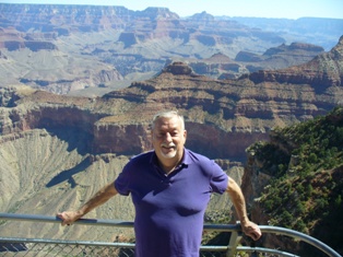
Grand Canyon in the Afternoon
Yvonne and Chuck
Layers of History
Trees clinging to the cliffs!
Overlooking the Grand Canyon!
Colorado River Winding throught the Canyon.
Yvonne
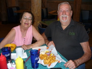
Lunch with new friends!
Zion National Park So off we drove to
Zion National Park. My sister
said originally that she was not interested in Zion but as we drove into
the park she suddenly said, "This is better than the Grand Canyon!"
The road going into the park
was a mess. Lots of road construction and sometimes 60 or
more cars stopped, waiting for the other cars to transverse the areas of
one lane. We were lucky as most of the time we were in the first
group to go through the road stoppages. We didn't take the shuttle as
it was over 100 degrees and my sister didn't feel up to it.
We did get lots of photos and I didn't miss the shuttle too much as it
was so hot. We got back to the hotel around
3:00 p.m. and got a room. We met two couples and had a nice
conversation, one couple from Milan Italy and the other from Seattle.
Zion National Park Overview
Zion National Park
This tunnel was constructed in 1930 and is 1.1 Miles Long!
Entering Zion National Park
The Sundial Mountains in the center.
Strange layers of rock formations.
View from the Visitor's Center.
These peaks looked like bee or wasp nests!
Chuck and His Favorite Sister, Yvonne!
Bryce Canyon & Coral Sand Dunes Park We
stopped for a late lunch and had to laugh, the cafe did not have mashed
potatoes and gravy, my sister's favorite. So the waiter went back
and asked his parents where we should to and they said a restaurant at
the Zion - Bryce Canyon junction. So we did stop there for a nice
meal. We had to laugh, the very cute waiter, blond and about 21
was asked about all the Indian artifacts on the walls and he said he
probably slept through the history classes in school. For some reason I said I had
been in the computer industry for over 40 years and he said again, he
took computer technology classes in school but either slept or ignored
the class! My sister and I agreed, if we went back in 20
years he would still be there handing out food except, my favorite
sister said, "Yes but, his tits would be sagging lower!"
We also stopped at the
Coral Sand Dunes Park, lots of sand
dunes colored salmon and lots of desert plants.
Bruce Canyon National Park Overview
Bryce is distinctive due to
geological structures called
hoodoos, formed by wind, water and ice
erosion of the river and lake bed
sedimentary rocks. The red, orange and white
colors of the
rocks provide spectacular vistas for park
visitors. Bryce is at a much higher elevation than
nearby
Zion National Park. The rim at Bryce varies from
8,000 to 9,000 feet (2,400 to 2,700 m). The Bryce
area was settled by
Mormon pioneers in the 1850s and was named after
Ebenezer Bryce, who
homesteaded in the area in 1874.
The area around Bryce Canyon became a
U.S. National Monument in 1923 and was
designated as a
national park in 1928. The park covers 56 square
miles (145 km2) and receives relatively
few visitors compared to Zion National Park and the
Grand Canyon, largely due to its remote location.
The town of
Kanab, Utah, is situated at a central point
between these three parks.
Bruce Canyon National Park
Entering the canyon.
Ourfirst look out!
Our first look out!
Sister and Brother enjoying the sights!
Afternoon colors.
Leaving Bryce Canyon
Coral Sand Dunes Park Overview
The Coral Pink Sand Dunes tiger beetle (Cicindela albissima) is endemic to the dunes, being found nowhere else in the world. The park also contains most of the remaining individuals of the rare plant known as Welsh's milkweed (Asclepias welshii), a federally listed threatened species.
Coral Sand Dunes Park
Pinkish Dunes!
Plants growing in just dry sand!
Stopping for Lunch as We Drove to Glen Canyon Dam
Strange Rock Formations
The Golden Hills Restaurant, at the Zion Bryce Junction!
A great restaurant and lots of local Indian souvenirs!
Entire Stock on Sale for ever and ever!
Glen Canyon Dam & Walnut Canyon Park In the front of the center was
a large slab of stone with foot prints of dinosaurs that were 20 feet
long, the dinosaurs, not the foot prints. We met a nice woman from
England who took our photo overlooking the dam and Lake Powell.
This river feeds Lake Powell and the Boulder Dam in Nevada by Las Vegas. We saw a road off of Flagstaff
that indicated the Walnut Canyon Park
with houses build about 1000 C.E. in the sides of cliffs. We
also saw the Sunset Crater Volcano, all in all, an interesting short
drive off the freeway. We were about 40 miles from
Tucson when I noticed a crack in the windshield! It was about
eight inches long, then later it was 12 inches and by the time I turned
the car in, it was about two feet long! It was covered by the
collision insurance at least!
Glen Canyon National Recreation Area Overview
Glen Canyon NRA borders Capitol Reef National Park and Canyonlands National Park on the north, Grand Staircase-Escalante National Monument on the west, Vermilion Cliffs National Monument and the northeasternmost reaches of Grand Canyon National Park on the southwest, and the Navajo Nation on the southeast. The southwestern end of Glen Canyon NRA in Arizona can be accessed via U.S. Route 89 and State Route 98. State Route 95 and State Route 276 lead to the northeastern end of the recreation area in Utah.
Glen Canyon NRA was established in 1972 "to provide for public use and enjoyment and to preserve the area's scientific, historic, and scenic features." The stated purpose of Glen Canyon NRA is for recreation as well as preservation (whereas a national park may carry more emphasis on natural preservation). As such, the area has been developed for access to Lake Powell via five marinas, four public campgrounds, two small airports, and numerous houseboat rental concessions.
Glen Canyon Park
Glen Canyon Dam
Glen Canyon Bridge
Lots of dinasours roamed this land!
Enjoying the View!
Walnut Canyon Park Overview
Walnut Canyon Park
A volcano ruined the land for miles!
This is the only building left after a thousand years!
The locals lived on steep hill sides, carrying water up the small paths.
Wupataki Native American houses along the steep cliffs.
Last Night on the Trip - Flagstaff Hotel and Restaurant!
The food at Mamma Luisa was great - next to the Best Western!
Enjoying spaghetti and a glass of wine!
We stayed at the Best Western hotel with a pool!
Sis got to use the Jacuzzi, the perfect thing after a long drive!
Indian Casino - Tucson
We did do the penny machines but
we each put in $20.00 and within about 15 minutes we were broke so off
we went back home. I decided to clean out the old
climbing vines on the porch and it took me about three hours in the 90
degree heat but I do like to be active so the porch looks a lot cleaner
and the vines will start to grow again from the cut off areas.
(Even if my sister doesn't believe it!) They have been growing
there for over ten years! We finally got to play cards as
we were so busy or tired we just forgot to play cards on our whirl wind
trip.
Indian Casino - Tucson
My sister loves to gamble at the Indian Casino!
They have a great cafe with reasonable prices! Lunch at the Thunder Canyon
Brewery
We have eaten there before and the
food is great and a good price. They brew their own beer there so
lots of choices to be had. We went back to Mary's condo
and spent the afternoon getting up to date. Later that afternoon we were
back home and Neal was in his room and Yvonne was out in the front yard.
I was sitting in the living room watching the news on TV when suddenly I
heard a horrible crash! I jumped out of the chair and yelled
out! The very heavy ceiling
fan/light, crashed onto the table where we play cards! The screws
in the ceiling gave way. We were lucky we weren't playing cards
and our heads would have been basked in by the fan blades. All in
all, very exciting. We did play cards for the last
time that night before I left for San Francisco the next morning.
Thunder Canyon Brewery
Thunder Canyon Brewery bar and restaurant!
A great lunch at the Thunder Canyon Brewery.
Tucson to Los Angeles and on
to San Francisco
Then on the plane a couple sat
next to me, from St. Louis. We had a long talk and they asked for
my card as they love to come to the City. I got home around 4:00
p.m. and down loaded my photos and relaxed and had dinner and to bed!
Another great trip!
Wonder where I will go next? India or Puerto Rica, time will tell!
The Grand Canyon
is a steep-sided
canyon carved by the
Colorado River in the
United States in the state of
Arizona. It is largely contained within the
Grand Canyon National Park, one of the first
national parks in the United States. President
Theodore Roosevelt was a major proponent of preservation of
the Grand Canyon area, and visited it on numerous occasions to
hunt and enjoy the scenery.


San
September
24,
2010
Day 4:
We arrived at Kanab Utah and stopped at the Red Feather Motel and found
out the office opened at 3:00 p.m. We asked if there would
be a room available and were told, yes.
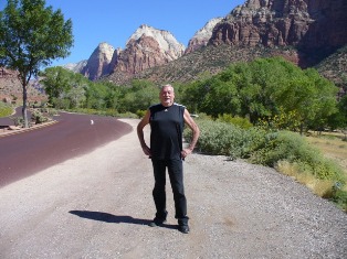
Zion National Park is a
national park located in the
Southwestern United States, near
Springdale, Utah. A prominent feature of the 229-square-mile
(593 km2) park is Zion Canyon, 15 miles (24 km) long
and up to half a mile (800 m) deep, cut through the reddish and
tan-colored
Navajo Sandstone by the North Fork of the
Virgin River.
The lowest elevation is 3,666 ft at Coal pits
Wash and the highest elevation is 8,726 ft at Horse Ranch
Mountain. Located at the junction of the
Colorado Plateau,
Great Basin, and
Mojave Desert regions, the park's unique
geography and variety of
life zones allow for unusual plant and animal diversity.
Numerous plant species as well as 289 species of birds, 75
mammals (including 19 species of
bat),
and 32 reptiles inhabit the park's four life zones:
desert, riparian, woodland, and
coniferous forest. Common plant species include
cottonwood, Cactus, Datura, Juniper, Pine, Boxelder, Sagebrush,
yucca, and various willows. Notable mega fauna include
mountain lions,
mule deer, and
Golden Eagles, along with the reintroduced
Bighorn Sheep. Zion´s also has rare and endangered species
such as the Peregrine Falcon, Mexican spotted owl, California
condor, desert tortoise, and the Zion snail, found nowhere else
on earth. Zion National Park includes mountains, canyons,
buttes, mesas,
monoliths, rivers,
slot canyons, and
natural arches.


San
September
25,
2010
Day 5:
Today we drove to Bryce Canyon and
enjoyed the sights. It was warm but not too hot. We drove
through about half of the park as my sister got tired and some of the
views were up steep hills. Even so, we had some great views and
photo opportunities.
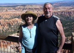
The major feature of
the park is Bryce Canyon which, despite its name, is not actually a
canyon but a giant natural
amphitheater created by
erosion along the eastern side of the Paunsaugunt Plateau.


Coral Pink Sand Dunes State Park is a state park in southwestern Utah, United States, located between Mount Carmel Junction and Kanab, south and west of U.S. Highway 89 in Kane County. The park features uniquely pink-hued sand dunes located beside red sandstone cliffs.
The dunes are formed from the erosion of pink-colored Navajo Sandstone surrounding the park. High winds passing through the notch between the Moquith and Moccasin Mountains pick up loose sand particles and then drop them onto the dunes as a result of the Venturi effect. The dunes are estimated to be between 10,000 and 15,000 years old. The park allows camping, hiking, off-road vehicle driving, and photography. There is a conservation area of 265 acres (1.07 km2), and the total grounds include 3,370 acres (13.6 km2). It was established as a Utah state park in 1963.


San
September
26,
2010
Day 6:
Today we left Kanab and started back to Page Arizona and on to
Flagstaff. Along the way we saw a sign that we were passing
the Glen Canyon Park with the
Glen Canyon Dam. So we thought, why not stop and
see the dam and visitor's center. We had a nice time viewing the
dam and reading about the history.

Glen Canyon National Recreation Area (shortened to Glen Canyon NRA or GCNRA) is a recreation and conservation unit of the United States National Park Service that encompasses the area around Lake Powell and lower Cataract Canyon in Utah and Arizona, covering 1,254,429 acres (5,076.49 km2) of mostly rugged high desert terrain. The recreation area is named for Glen Canyon, which was flooded by the Glen Canyon Dam, completed in 1966, and is now mostly submerged beneath the waters of Lake Powell.


Walnut Canyon National Monument (Hopi: Wupatupqa) is a United States National Monument located about 10 mi (16 km) southeast of downtown Flagstaff, Arizona, near Interstate 40. The canyon rim elevation is 6,690 ft (2,040 m); the canyon's floor is 350 ft lower. A 0.9 mi (1.4 km) long loop trail descends 185 ft (56 m) into the canyon passing 25 cliff dwelling rooms constructed by the Sinagua, a pre-Columbian cultural group that lived in Walnut Canyon from about 1100 to 1250 AD. Other contemporary habitations of the Sinagua people are preserved in the nearby Tuzigoot and Montezuma Castle national monuments.


We were very tired and decided to stop on the last day and get a room at a motel instead of trying to drive to Tucson. We had a nice dinner and decided to use the swimming pool. Suddenly we had a good laugh, we realized we had stayed at the same motel a few years ago when we did a southwestern tour to New Mexico!


San
September
27,
2010
Day 7:
Today we relaxed in Tucson and then decided to go the local
Indian
Casino for lunch. They have a great cafe that looks like a 1960's
restaurant with music and decorations to match.


San
September
28,
2010
Day 8:
Today we visited a friend of ours, Mary and her husband. Mary
joined up for lunch at a local shopping center -
Thunder Canyon Brewery.


San
September
29,
2010
Day 9:
The plane was delayed again, but not enough for me to miss my flight to
LAX and on to SFO. I met a young Taiwanese man who deals in
specialty saloon hair care products and skin care and gave me his card.
He said he would send my samples of skin care for me to try.
San
Created on: 2010.08.15

Updated on: 2020.09.20