Maps of the Hawaiian Islands:
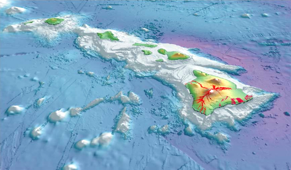
This map shows the Hawaiian Islands as they appear when rising from the bottom of the Pacific Ocean! A great eyes view from space! It also shows the volcanic areas of the islands.
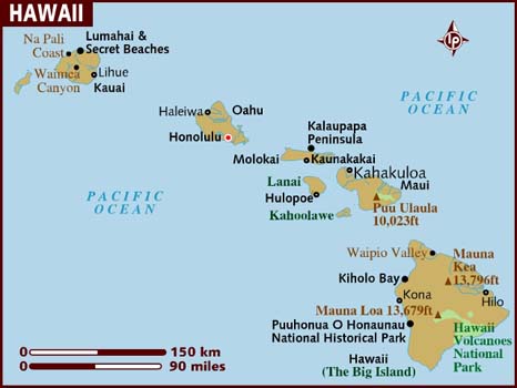
This map shows Hawaii's 5 counties. Also available is a detailed Hawaii County Map with county seat cities.
Counties of Hawaii:
Hawaii County includes the Island of Hawaii, also called the "Big Island."
Maui County includes the islands of Maui
Molokai (except the Kalaupapa Peninsula)
Lanai
Kahoolawe
Molokini.
Kalawao County is located on the Kalaupapa Peninsula of Molokai Island.
Honolulu County includes the island of Oahu and also the Northwestern Hawaiian Islands (except Midway Atoll, which is considered a U.S. Territory and is not part of the state of Hawaii). The Northwestern Hawaiian Islands (sometimes called the Leeward Islands) are several small islands and atolls which lie northwest of Kauai County.
Kauai County includes the islands of Kauai, Niihau, Lehua, and Kaula.
History
In 1778, Captain James Cook arrived at Waimea Bay, the first European known to have reached the Hawaiian islands. He named the archipelago after his patron the 6th Earl of Sandwich, George Montagu.
During the reign of King Kamehameha, the islands of Kauai and Niihau were the last Hawaiian Islands to join his Kingdom of Hawaii. Their ruler, Kaumualii, resisted Kamehameha for years. King Kamehameha twice prepared a huge armada of ships and canoes to take the islands by force, and twice failed; once due to a storm, and once due to an epidemic. In the face of the threat of a further invasion, however, Kaumualii decided to join the kingdom without bloodshed, and became Kamehameha's vassal in 1810. He ceded the island to the Kingdom of Hawaii upon his death in 1824.
Schäffer affair
In 1815, a ship from the Russian-American Company was wrecked on the island. In 1816, an agreement was signed by Kaumualii to allow the Russians to build Fort Elizabeth. It was an attempt by Kaumuali’i to gain support from the Russians against Kamehameha I. Construction was begun in 1817, but in July of that year under mounting resistance of Native Hawaiians and American traders the Russians were expelled. The settlement on Kauai has been considered an abrupt instance of a Pacific outpost of the Russian Empire per se.
Valdemar Knudsen
Valdemar Knudsen
Valdemar Emil Knudsen was a Norwegian plantation pioneer who arrived on Kauai in 1857. Knudsen, or "Kanuka", originally arrived in Koloa where he managed Grove Farm, but later sought a warmer land and purchased the leases to Mana and Kekaha, where he became a successful sugarcane plantation owner. Knudsen settled in Waiawa, between Mana and Kekaha, immediately across the channel from Niihau Island. His son, Eric Alfred Knudsen, was born in Waiawa.
Knudsen was appointed land administrator by King Kamehameha for an area covering 400 km2, and was given the title konohiki as well as a position as a nobility under the king. Knudsen, who spoke fluent Hawaiian, later became an elected representative and an influential politician on the island.
Knudsen lends his name to the Knudsen Gap, a narrow pass between Hã’upu Ridge and the Kahili Ridge. Its primary function was as a sugar farm planted by the Knudsen family
Old Sugar Mill of Koloa
In 1835, Old Koloa Town opened a sugar mill. From 1906 to 1934 the office of County Clerk was held by John Mahiai Kaneakua, who had been active in attempts to restore Queen Liliuokalani to the throne after the United States takeover of Hawaii in 1893.
Etymology and language
Geography
Kauai's origins are volcanic, the island having been formed by the passage of the Pacific Plate over the Hawaii hotspot. At approximately five million years old, it is the oldest of the main islands. The highest peak on this mountainous island is Kawaikini at 5,243 feet (1,598 m).
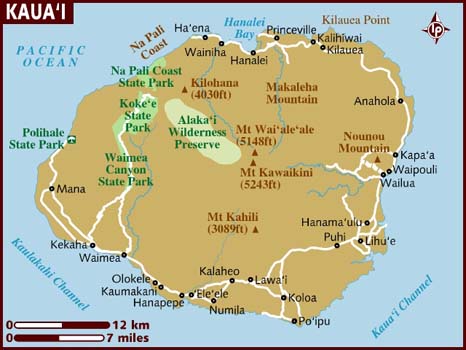
The second highest peak is Mount Waialeale near the center of the island, 5,148 ft (1,569 m) above sea level. One of the wettest spots on earth, with an annual average rainfall of 460 inches (1,200 cm), is located on the east side of Mount Waialeale. The high annual rainfall has eroded deep valleys in the central mountains, carving out canyons with many scenic waterfalls. On the west side of the island, Waimea town is located at the mouth of the Waimea River, whose flow formed Waimea Canyon, one of the world's most scenic canyons, which is part of Waimea Canyon State Park. At 3,000 ft (914 m) deep, Waimea Canyon is often referred to as "The Grand Canyon of the Pacific". Kokeo Point lies on the south side of the island. The Na Pali Coast is a center for recreation in a wild setting, including kayaking past the beaches, or hiking on the trail along the coastal cliffs. The headland, Kuahonu Point, is on the south-east of the island.
Hawaiian narrative locates the name's origin in the legend of Hawaiiloa, the Polynesian navigator credited with discovery of the Hawaiian Islands. The story relates how he named the island of Kauai after a favorite son; a possible translation of Kauai is "place around the neck", describing how a father would carry a favorite child. Another possible translation is "food season".
Kauai was known for its distinct dialect of the Hawaiian language; this survives on Niihau. While the standard language today adopts the dialect of Hawaii island, which has the sound, the Kauai dialect was known for pronouncing this as [t]. In effect, Kauai dialect retained the old pan-Polynesian /t/, while "standard" Hawaii dialect has changed it to the. Therefore, the native name for Kauai was said as Tauai, and the major settlement of Kapaa would have been pronounced as Tapaa.
Geography - Kalalau Beach
Kauai's origins are volcanic, the island having been formed by the passage of the Pacific Plate over the Hawaii hotspot. At approximately five million years old, it is the oldest of the main islands. The highest peak on this mountainous island is Kawaikini at 5,243 feet (1,598 m).
The second highest peak is Mount Waialeale near the center of the island, 5,148 ft (1,569 m) above sea level. One of the wettest spots on earth, with an annual average rainfall of 460 inches (1,200 cm), is located on the east side of Mount Waialeale. The high annual rainfall has eroded deep valleys in the central mountains, carving out canyons with many scenic waterfalls. On the west side of the island, Waimea town is located at the mouth of the Waimea River, whose flow formed Waimea Canyon, one of the world's most scenic canyons, which is part of Waimea Canyon State Park. At 3,000 ft (914 m) deep, Waimea Canyon is often referred to as "The Grand Canyon of the Pacific". Kokeo Point lies on the south side of the island. The Na Pali Coast is a center for recreation in a wild setting, including kayaking past the beaches, or hiking on the trail along the coastal cliffs. The headland, Kuahonu Point, is on the south-east of the island.


