

|
|
|
|
I have had many places I wished to visit on my Bucket List and here are just a few that I so far, have had the good fortune to tour. The Great Wall of China, the ruins of Machu Pichu in Peru, the Statues on Easter Island and of course the Pyramids of Egypt!I finally took a trip to Alcatraz after 40 years of living in San Francisco. Now I decided to take a day cruise to the Farallone Islands off the west coast of San Francisco, a true rarity of a sanctuary of birds, fish and mammals. This to celebrate my living in the City for over 50 years now!
We always have a good laugh about the islands as they and Los Angeles are located on the Pacific Plate and are slowly sliding north past the City and the North American Continental Plate. In a few million years L.A. will be 50 miles or so west of us!
Currenly we are in the biggest drought in known recording of rain fall in California. It has been 80 degrees or more in the City. As you can see in the photo, the Pacific Ocean was flat as a rock and there wasn't any wind. It must have been 70 degrees on the boat and one only needed a light jacket or if sitting in the sun, just a light shirt. The captain of the ship said this was one of the best cruises he had ever had due to the wonderful weather.
This tour can be accessed on the following web site: San Francisco Whale Tours or call 800.979.3370 - 415.706.7364.
We saw the following as we cruised to the Farallon Islands:
- Humpback Whale
- Harbor Porpoises
- Pacific Harbor Seals
- Northern Elephant Seals
- Blue Footed Booby
- California Gull
- Elegant Tern
- Common Tern
- Double Crested Cormorant
- Brown Pelican
- Pelagie Cormorant
- Common Murre
- Common Loon

|
|
Chucks Down Town View Before Leaving to Cruise to the Farallon Islands |

|
|
View of the San Francisco Skyline with Temperatures in the 80s and no wind! |

|
|
Golden Gate Bridge and the Headlands of Marin |
A Short History of the Golden Gate Bridge
The Frommers travel guide considers the Golden Gate Bridge "possibly the most beautiful, certainly the most photographed, bridge in the world". It opened in 1937 and had, until 1964, the longest suspension bridge main span in the world, at 4,200 feet (1,300 m).
Strauss was chief engineer in charge of overall design and construction of the bridge project. However, because he had little understanding or experience with cable-suspension designs, responsibility for much of the engineering and architecture fell on other experts. Strauss' initial design proposal (two double cantilever spans linked by a central suspension segment) was unacceptable from a visual standpoint. The final graceful suspension design was conceived and championed by New York’s Manhattan Bridge designer Leon Moisseiff.
Ellis was a Greek scholar and mathematician who at one time was a University of Illinois professor of engineering despite having no engineering degree. He eventually earned a degree in civil engineering from the University of Illinois prior to designing the Golden Gate Bridge and spent the last twelve years of his career as a professor at Purdue University. He became an expert in structural design, writing the standard textbook of the time. Ellis did much of the technical and theoretical work that built the bridge, but he received none of the credit in his lifetime. In November 1931, Strauss fired Ellis and replaced him with a former subordinate, Clifford Paine, ostensibly for wasting too much money sending telegrams back and forth to Moisseiff. Ellis, obsessed with the project and unable to find work elsewhere during the Depression, continued working 70 hours per week on an unpaid basis, eventually turning in ten volumes of hand calculations.
With an eye toward self-promotion and posterity, Strauss downplayed the contributions of his collaborators who, despite receiving little recognition or compensation,[20] are largely responsible for the final form of the bridge. He succeeded in having himself credited as the person most responsible for the design and vision of the bridge. Only much later were the contributions of the others on the design team properly appreciated. In May 2007, the Golden Gate Bridge District issued a formal report on 70 years of stewardship of the famous bridge and decided to give Ellis major credit for the design of the bridge.
The Golden Gate Bridge is a suspension bridge spanning the Golden Gate strait, the mile-wide, three-mile-long channel between San Francisco Bay and the Pacific Ocean. The structure links the U.S. city of San Francisco,
 on the northern tip of the San Francisco Peninsula, to Marin County, bridging both U.S. Route 101 and California State Route 1 across the strait. The bridge is one of the most internationally recognized symbols of San Francisco, California, and the United States. It has been declared one of the Wonders of the Modern World by the American Society of Civil Engineers.

|
Golden Gate Bridge and Fort Point
Mexico won independence from Spain in 1821, gaining control of the region and the fort, but in 1835 the Mexican army moved to Sonoma leaving the castillo's adobe walls to crumble in the wind and rain. On July 1, 1846, after the Mexican-American War broke out between Mexico and the United States, U.S. forces, including Captain John Charles Fremont, Kit Carson and a band of 10 followers, captured and occupied the empty castillo and spiked (disabled) the cannons.
Following the United States' victory in 1848, California was annexed by the U.S. and became a state in 1850. The gold rush of 1849 had caused rapid settlement of the area, which was recognized as commercially and strategically valuable to the US. Military officials soon recommended a series of fortifications to secure San Francisco Bay. Coastal defenses were built at Alcatraz Island, Fort Mason, and Fort Point.
The U.S. Army Corps of Engineers began work on Fort Point in 1853. Plans specified that the lowest tier of artillery be as close as possible to water level so cannonballs could ricochet across the water's surface to hit enemy ships at the water-line. Workers blasted the 90-foot (27 m) cliff down to 15 feet (4.6 m) above sea level. The structure featured seven-foot-thick walls and multi-tiered casemated construction typical of Third System forts. It was sited to defend the maximum amount of harbor area. While there were more than 30 such forts on the East Coast, Fort Point was the only one on the West Coast. In 1854 Inspector General Joseph K. Mansfield declared "this point as the key to the whole Pacific Coast...and it should receive untiring exertions".
A crew of 200, many unemployed miners, labored for eight years on the fort. In 1861, with war looming, the army mounted the fort's first cannon. Colonel Albert Sidney Johnston, commander of the Department of the Pacific, prepared Bay Area defenses and ordered in the first troops to the fort. Kentucky-born Johnston then resigned his commission to join the Confederate Army; he was killed at the Battle of Shiloh in 1862.
In 1769 Spain occupied the San Francisco area and by 1776 had established the area's first European settlement, with a mission and a presidio. To protect against encroachment by the British and Russians, Spain fortified the high white cliff at the narrowest part of the bay's entrance, where Fort Point now stands. The Castillo de San Joaquin, built in 1794, was an adobe structure housing nine to thirteen cannons.


|
|
Point Bonita Light House |
The original Point Bonita Lighthouse, a 56-foot (17 m) brick tower, was located too high. Unlike the East Coast of the United States, the West Coast has dense high fog, which leaves lower elevations clear.
The original light was 306 feet (93 m) above sea level so the second order Fresnel lens was often cloaked in fog and could not be seen from the sea. In 1877, the lighthouse was moved to its current location at 124 feet (38 m) above sea level.
The United States Coast Guard currently maintains the light and fog signal. It is accessible to the public during limited hours (12:30 PM–3:30 PM) on Saturdays, Sundays, and Mondays. Up until 1940 the lighthouse could be reached without a bridge, but erosion caused a trail leading to the lighthouse to crumble into the sea. A wooden walkway was installed, but when that became treacherous the suspension bridge was built in 1954.
As of January 6, 2010, the suspension bridge to the light house was closed to public access. According to the Federal Highway Administration, the bridge, which was 56 years old, started to rust. It underwent repairs in 1979 and again in 1991, but the metal components were not able to stand up to the sea spray. The new span reopened April 13, 2012. The new bridge construction cost a bit over $1 million. It is made of tropical hardwood with steel suspension cables and attachments.
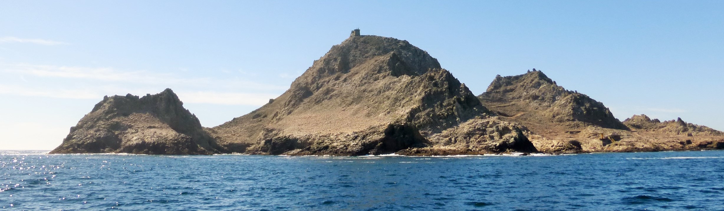
Farallon Islands
The Gulf of the Farallones National Marine Sanctuary
-
GFNMS
-
is one of 13 marine sanctuaries in the U.S., found outside San Francisco's Golden Gate surrounding the Gulf of the Farallones.
We Saw One Humpback Whale Who Repeatedly Surfaced for Over Ten Minutes!
Sea Lions
Pelicans
Cormorants and the Common Murre
Rugged Rocks and Caves Carved out by the Salty Sea Water
Calm Seas and Sun Shine
Sailing Back Into San Francisco - Coit Tower and the Port The history of the city of San Francisco, California, and its development as a center of maritime trade, have been greatly influenced by its location at the entrance to one of the world's best natural harbors. San Francisco is the name of both the city and the county, which share the same boundaries.
The first Native Americans to settle this region found the bay to be a vast natural resource for hunting and gathering their provisions and for the establishment of many small villages. Collectively, these early Native Americans were known as the Ohlone, and the language they spoke belonged to the Miwok family. Their trade patterns included places as far away as Baja California, the Mojave Desert and Yosemite.
The first Europeans in the vicinity of what would become San Francisco were members of a Spanish exploratory voyage led by Juan Rodriguez Cabrillo. Cabrillo, sailing north from Mexico, explored the coast as far north as present-day Point Reyes, but failed to discover the entrance to San Francisco Bay. An English expedition led by Sir Francis Drake may also have sailed past the bay entrance, in 1579. Drake mapped the coast farther north at Drake's Bay, naming the area "Nova Albion", but made little effort to claim or settle the land.
The earliest Europeans to reach the future site of San Francisco by land were a Spanish exploratory party in 1769, led north from Mexico by Don Gaspar de Portolà and Fra. Juan Crespi. The Spanish found this location to be of great strategic significance, and a follow-up land expedition led by Juan Bautista de Anza selected sites for both military and religious settlements in 1774. The Presidio of San Francisco was established to be the center of military activities, while Mission San Francisco de Asís began the cultural/religious conversion of some 10,000 Ohlone who lived in the area. The mission was also known as Mission Dolores because of its nearness to a creek named after Our Lady of Sorrows.
The first ship anchorage was established at a small inlet on the north-east end of the peninsula (later filled: now lower Market Street), and the small settlement that grew up nearby was named Yerba Buena, after the herb of the same name that grew in abundance there. The original plaza of the Spanish settlement remains today as Portsmouth Square. Today's city took its name from the Mission, and Yerba Buena remained the name of a San Francisco neighborhood also known as South of Market. The Moscone Center and Yerba Buena Gardens are in the Yerba Buena area. In addition, the name Yerba Buena was appl to the former Goat Island in the middle of San Francisco Bay, adjacent to Treasure Island.
San Francisco became part of the United States with the signing of the Treaty of Guadalupe Hidalgo in 1848. San Francisco is now estimated to be the twelfth largest city in the United States, and has been characterized by rapid economic change and cultural diversity.
Point Bonita Lighthouse is a lighthouse located at Point Bonita at the San Francisco Bay entrance in the Marin Headlands near Sausalito, California.
 Point Bonita was the last manned lighthouse on the California coast.

The Farallon Islands, or Farallones (from the Spanish farallón meaning "pillar" or "sea cliff"), are a group of islands and sea stacks in the Gulf of the Farallones and the islands are about 30 miles west of the
Golden Gate Bridge!


Created on: 2014

Updated on: 2020.08.31